![](/images/other/stat-length.png)
![Trail On foot Marktgemeinde Fieberbrunn - Fieberbrunn - Hochkogel - Photo](https://media.geolcdn.com/t/1900/400/ext.pjpeg?maxdim=2&url=https%3A%2F%2Fmedia.geolcdn.com%2Ff%2F1092cf09-bbc9-47cc-b619-1816d413fc1a.jpeg)
Fieberbrunn - Hochkogel
SityTrail - itinéraires balisés pédestres
Tous les sentiers balisés d’Europe PRO
![Length](/images/other/stat-length.png)
Length
7.4 km
![Max alt](https://static1.geolcdn.com/siteimages/upload/files/1508320355ic_sort_altitude_max_24dp.png)
Max alt
1057 m
![Uphill gradient](https://static1.geolcdn.com/siteimages/upload/files/1508320355ic_sort_den_pos_24dp.png)
Uphill gradient
295 m
![Km-Effort](/images/other/stat-length.png)
Km-Effort
11.3 km
![Min alt](https://static1.geolcdn.com/siteimages/upload/files/1508320355ic_sort_altitude_min_24dp.png)
Min alt
763 m
![Downhill gradient](https://static1.geolcdn.com/siteimages/upload/files/1508320355ic_sort_den_neg_24dp.png)
Downhill gradient
295 m
![Boucle](https://static1.geolcdn.com/siteimages/upload/files/16400158638029165_repeat_loop_refresh_sync_direction_icon.png)
Boucle
Yes
Signpost
Creation date :
2022-02-16 17:25:07.44
Updated on :
2022-03-03 20:01:02.58
![On foot](https://static1.geolcdn.com/sitytour/trail-icons/100.png)
2h34
Difficulty : Easy
![Scan this QR Code to open this trail in the SityTrail application](https://capi.geolives.com/qq0zvz2zws4bq2lad0pu/sitytour/trails/3129570/qr.png?size=200)
FREE GPS app for hiking
About
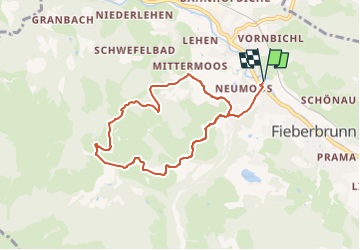
Trail On foot of 7.4 km to be discovered at Tyrol, Bezirk Kitzbühel, Marktgemeinde Fieberbrunn. This trail is proposed by SityTrail - itinéraires balisés pédestres.
Description
Trail created by Infrastrukturbetriebe Fieberbrunn.
Symbol: am Wegrand horizontal rot-weiß-rot
Positioning
Country:
Austria
Region :
Tyrol
Department/Province :
Bezirk Kitzbühel
Municipality :
Marktgemeinde Fieberbrunn
Location:
Unknown
Start:(Dec)
Start:(UTM)
314432 ; 5261661 (33T) N.
Comments
Trails nearby
![Trail On foot Marktgemeinde Fieberbrunn - [12] Fieberbrunn Jägersteig - Photo](https://media.geolcdn.com/t/375/260/ext.jpg?maxdim=2&url=https%3A%2F%2Fmedia.geolcdn.com%2Ff%2F9edda448-f93a-4af8-b4d9-b9ec1461bad0.jpeg)
![On foot On foot](https://static1.geolcdn.com/sitytour/trail-icons/100.png)
[12] Fieberbrunn Jägersteig
On foot
Easy
Marktgemeinde Fieberbrunn,
Tyrol,
Bezirk Kitzbühel,
Austria
![](/images/other/stat-length.png)
4.5 km | 8.6 km-effort
1h 57min
![](https://static1.geolcdn.com/siteimages/upload/files/16400158638029165_repeat_loop_refresh_sync_direction_icon.png)
No
![Trail On foot Marktgemeinde Fieberbrunn - [2] Fieberbrunner Höhenweg - Photo](https://media.geolcdn.com/t/375/260/ext.jpg?maxdim=2&url=https%3A%2F%2Fmedia.geolcdn.com%2Ff%2Fe8040533-add9-44ec-957a-500c7078819f.jpeg)
![On foot On foot](https://static1.geolcdn.com/sitytour/trail-icons/100.png)
[2] Fieberbrunner Höhenweg
On foot
Difficult
Marktgemeinde Fieberbrunn,
Tyrol,
Bezirk Kitzbühel,
Austria
![](/images/other/stat-length.png)
24 km | 37 km-effort
8h 18min
![](https://static1.geolcdn.com/siteimages/upload/files/16400158638029165_repeat_loop_refresh_sync_direction_icon.png)
No
![Trail On foot Marktgemeinde Fieberbrunn - [1] Fieberbrunn - Wanderschuh - Photo](https://media.geolcdn.com/t/375/260/ext.jpg?maxdim=2&url=https%3A%2F%2Fmedia.geolcdn.com%2Ff%2Ffd03419b-07ff-495d-9845-bd674901fd7c.jpeg)
![On foot On foot](https://static1.geolcdn.com/sitytour/trail-icons/100.png)
[1] Fieberbrunn - Wanderschuh
On foot
Easy
Marktgemeinde Fieberbrunn,
Tyrol,
Bezirk Kitzbühel,
Austria
![](/images/other/stat-length.png)
3.2 km | 4.3 km-effort
58min
![](https://static1.geolcdn.com/siteimages/upload/files/16400158638029165_repeat_loop_refresh_sync_direction_icon.png)
No
![Trail On foot Marktgemeinde Fieberbrunn - [3] Fieberbrunn - Karstein - Photo](https://media.geolcdn.com/t/375/260/ext.jpg?maxdim=2&url=https%3A%2F%2Fmedia.geolcdn.com%2Ff%2F3deaf227-084c-4bb2-b343-4239f2614f36.jpeg)
![On foot On foot](https://static1.geolcdn.com/sitytour/trail-icons/100.png)
[3] Fieberbrunn - Karstein
On foot
Difficult
Marktgemeinde Fieberbrunn,
Tyrol,
Bezirk Kitzbühel,
Austria
![](/images/other/stat-length.png)
22 km | 38 km-effort
8h 32min
![](https://static1.geolcdn.com/siteimages/upload/files/16400158638029165_repeat_loop_refresh_sync_direction_icon.png)
Yes
![Trail On foot Marktgemeinde Fieberbrunn - [9] Streuböden Talstation - Lärchfilzhochalm - Photo](https://media.geolcdn.com/t/375/260/ext.jpg?maxdim=2&url=https%3A%2F%2Fmedia.geolcdn.com%2Ff%2Ff09ad1e6-3848-479a-a1b9-336695037d7f.jpeg)
![On foot On foot](https://static1.geolcdn.com/sitytour/trail-icons/100.png)
[9] Streuböden Talstation - Lärchfilzhochalm
On foot
Easy
Marktgemeinde Fieberbrunn,
Tyrol,
Bezirk Kitzbühel,
Austria
![](/images/other/stat-length.png)
4.1 km | 9.4 km-effort
2h 8min
![](https://static1.geolcdn.com/siteimages/upload/files/16400158638029165_repeat_loop_refresh_sync_direction_icon.png)
No
![Trail On foot Marktgemeinde Fieberbrunn - [4] Gebraweg - Photo](https://media.geolcdn.com/t/375/260/ext.jpg?maxdim=2&url=https%3A%2F%2Fstatic1.geolcdn.com%2Fsiteimages%2Fupload%2Ffiles%2F1545311037marcheuse_200dpi.jpg)
![On foot On foot](https://static1.geolcdn.com/sitytour/trail-icons/100.png)
[4] Gebraweg
On foot
Easy
Marktgemeinde Fieberbrunn,
Tyrol,
Bezirk Kitzbühel,
Austria
![](/images/other/stat-length.png)
3.9 km | 9.7 km-effort
2h 11min
![](https://static1.geolcdn.com/siteimages/upload/files/16400158638029165_repeat_loop_refresh_sync_direction_icon.png)
No
![Trail On foot Marktgemeinde Fieberbrunn - [7] Fieberbrunn - Zielstatt - Photo](https://media.geolcdn.com/t/375/260/ext.jpg?maxdim=2&url=https%3A%2F%2Fstatic1.geolcdn.com%2Fsiteimages%2Fupload%2Ffiles%2F1545311037marcheuse_200dpi.jpg)
![On foot On foot](https://static1.geolcdn.com/sitytour/trail-icons/100.png)
[7] Fieberbrunn - Zielstatt
On foot
Easy
Marktgemeinde Fieberbrunn,
Tyrol,
Bezirk Kitzbühel,
Austria
![](/images/other/stat-length.png)
3.2 km | 7 km-effort
1h 34min
![](https://static1.geolcdn.com/siteimages/upload/files/16400158638029165_repeat_loop_refresh_sync_direction_icon.png)
No
![Trail Other activity Marktgemeinde Fieberbrunn - Fieberbrunn 2 - Photo](https://media.geolcdn.com/t/375/260/ext.jpg?maxdim=2&url=https%3A%2F%2Fservices.sitytrail.com%2FGeolivesWS%2FDownloadMedia.ashx%3FTrailID%3D816179%26Media%3D20170823150943.jpg)
![Other activity Other activity](https://static1.geolcdn.com/sitytour/trail-icons/900.png)
Fieberbrunn 2
Other activity
Easy
Marktgemeinde Fieberbrunn,
Tyrol,
Bezirk Kitzbühel,
Austria
![](/images/other/stat-length.png)
10.6 km | 16.4 km-effort
3h 20min
![](https://static1.geolcdn.com/siteimages/upload/files/16400158638029165_repeat_loop_refresh_sync_direction_icon.png)
Yes
![Trail Other activity Marktgemeinde Fieberbrunn - vers le lac - Photo](https://media.geolcdn.com/t/375/260/ext.jpg?maxdim=2&url=https%3A%2F%2Fservices.sitytrail.com%2FGeolivesWS%2FDownloadMedia.ashx%3FTrailID%3D816379%26Media%3D20170824124635.jpg)
![Other activity Other activity](https://static1.geolcdn.com/sitytour/trail-icons/900.png)
vers le lac
Other activity
Very easy
Marktgemeinde Fieberbrunn,
Tyrol,
Bezirk Kitzbühel,
Austria
![](/images/other/stat-length.png)
4.7 km | 10.2 km-effort
2h 30min
![](https://static1.geolcdn.com/siteimages/upload/files/16400158638029165_repeat_loop_refresh_sync_direction_icon.png)
No